Metrolink rental map: Manchester digital media company create cost guide for one-bedroom flat
12-06-2015
By Rhian Lubin
Kirsty Allen created the map after she was inspired by a similar London Underground rental map
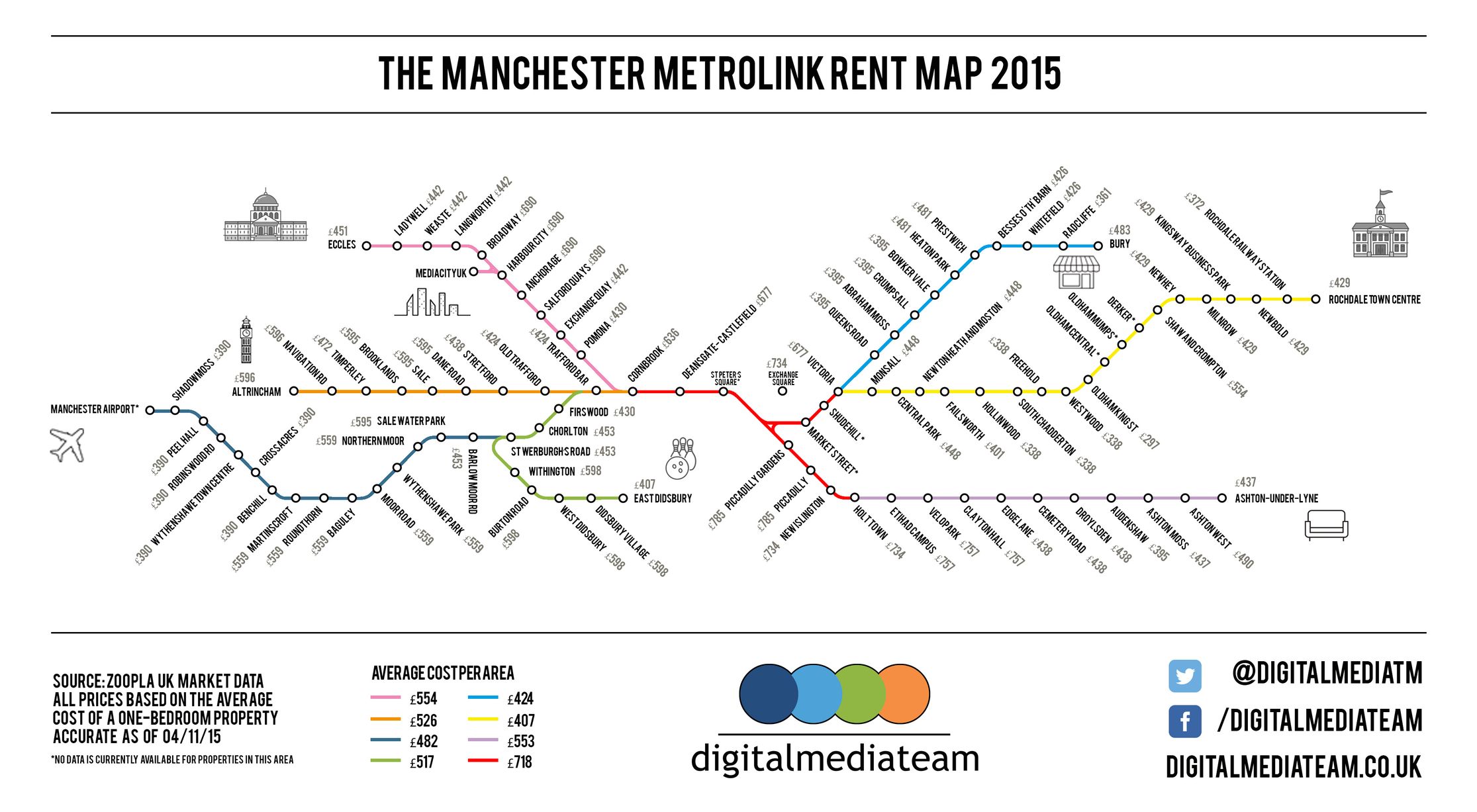
A digital media company has created a Metrolink rental map showing how much it costs to rent a flat in Greater Manchester.
The innovative map copies the layout of the Metrolink service map and shows the average price to rent a one-bedroom flat.
It was created by 26-year-old creative copywriter Kirsty Allen, who works for the Digital Media Team company.
Kirsty, from Salford, said: “We wanted to create something interesting that would draw people to our site.
“It’s got people debating already. It isn’t a full guide, but there’s definitely potential for us to expand it into different sized properties.
Average cost for renting per month on each line:

Average price of renting one bed flat
AltrinchamEcclesManchester AirportEast Didsbury City ZoneBuryRochdaleAshton under LyneArea0100200300400500600700800Cost (£)
“The data was collected from Zoopla and is up to date. It’s just a good way visually of showing the data.”
Kirsty said she was inspired by online magazine Thrillist which created a London Underground rental map.
She said: “I saw the map on Thrillist and couldn’t believe how expensive some areas were for renting.
“It costs £2,920pcm for a one-bed at Hyde Park Corner.
“I thought I could do the same for Manchester. It’s not as expensive as London but some areas near the city centre are dearer.”
Mark Waugh
The most expensive areas on the map are in the City Zone, with a one-bedroom flat costing £785 in Piccadilly Gardens per month to rent.
Exchange Square was the second most expensive area to rent at £734 per month.
At the other end of the spectrum the cheapest places to rent are between Manchester Airport and Barlow Moor Road, with flats in Shadowmoss, Peel Hall, Robinswood, Wythenshawe Town Centre, Crossacres and Benchill costing £390 per month.
www.manchestereveningnews.co.uk

